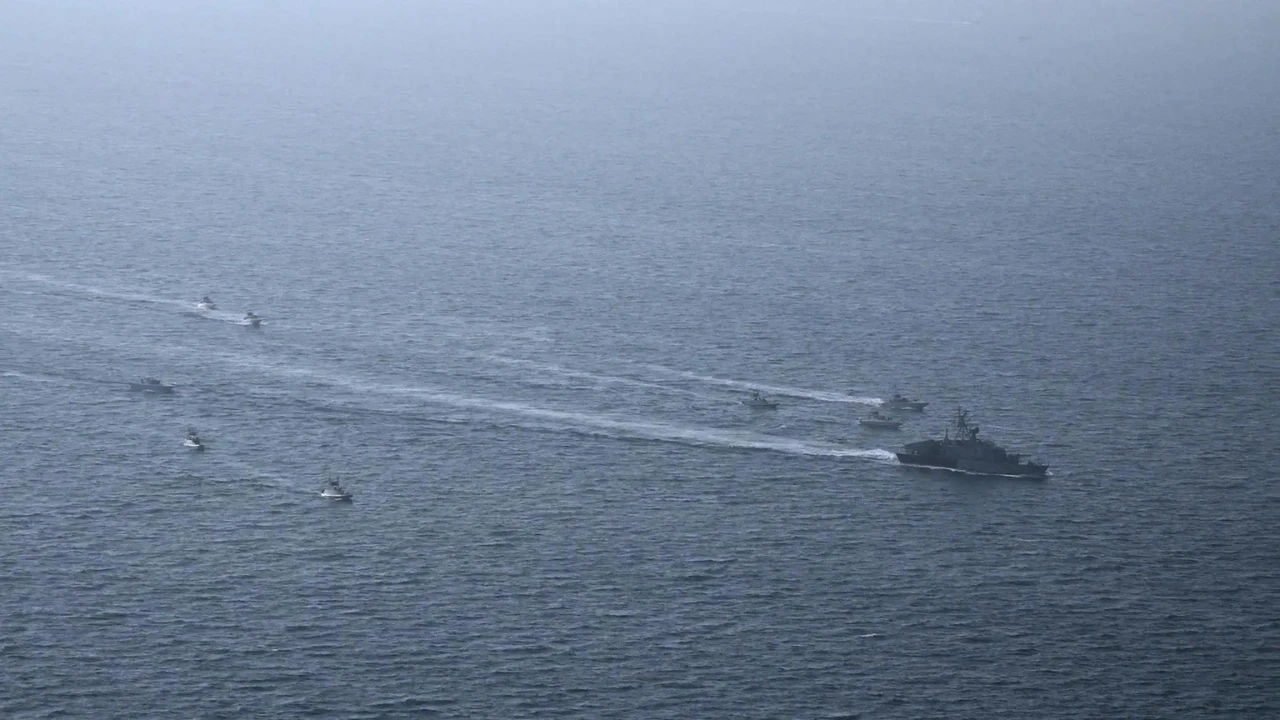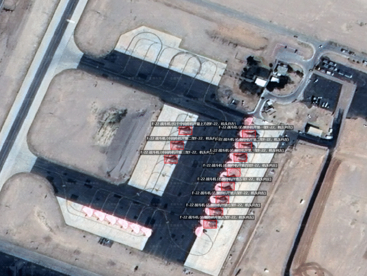
Even before the first missile was launched on Iran on February 28, there were indications on Chinese social media that the United States was preparing for a major attack. Satellite images of U.S. military preparations began circulating rapidly on the Internet. The images showed fighter jets parked on the runway, transport planes landing on a desert airfield and fighter jets stationed on the deck of an aircraft carrier in the Mediterranean. What was special about these pictures was that they contained an unusually large amount of information, and this information was written in Mandarin, not English. The photographs showed the names of different aircraft, the missile defense system was clearly marked, and the deployment of troops was shown with a precise location. These satellite images were shared online by a Chinese artificial intelligence company. In one picture, Lockheed Martin's F-22 stealth fighters were seen standing at Israel's Ovada Air Base. The second image showed an increasing deployment of aircraft and support systems at Prince Sultan Air Base in Saudi Arabia. U.S. military bases in Qatar, Jordan and Bahrain were also marked on the map. The images were shared by Shanghai-based geospatial intelligence company Mizar Vision, which employs less than 200 people. On February 28, the United States and Israel jointly launched air strikes on Iran under "Operation Epic Fury". In response, Tehran launched missile and drone strikes. But in the midst of this struggle, one more thing was going on in parallel. Satellite images were constantly popping up on the Internet, showing the activities of US planes, missile defense systems and naval forces. All these images were being shared by Shanghai-based geospatial intelligence company Mizar Vision. It is said that the first large set of pictures surfaced around February 20. Mizar Vision released a collection of high-resolution satellite images, showing the deployment of US planes at the Ovada Air Base in southern Israel, the presence of fighter jets in several countries in the Middle East, including Saudi Arabia and Qatar, naval movements in the Arabian Sea and movement of aircraft carriers. Various information was also added to all these pictures with the help of Artificial Intelligence. Types of aircraft were stated, support aircraft were identified and missile defense systems were also identified. By March 1, the data had risen even further. Mizar Vision also released new satellite images of military bases in Jordan, Kuwait, Bahrain and the United Arab Emirates. These pictures also showed different types of aircraft, air defense systems and deployment of troops. These satellite images were posted on social media platform X and Chinese platform Weibo with exact location. Many of these posts were also shared by accounts affiliated with Chinese state media and analysts associated with the People's Liberation Army (PLA). In these pictures, many important military platforms of the United States were seen. Satellite images showed F-22 stealth fighters standing at Israel's Ovada Air Base, just in time for the war to begin. According to the pictures, seven F-22 aircraft were parked near the runway and four other F-22s were visible on the runway. About 24 hours later, "Operation Epic Fury" began. Other pictures also showed military activities at Saudi Arabia's Prince Sultan Air Base. Seven Boeing E-3 Airborne Warning and Control System aircraft and two Bombardier E-11 communication aircraft are said to be deployed here. Satellite images of Qatar's Al-Udeed Air Base were also released. Later, the same air base was the target of Iranian missile and drone attacks. However, these pictures were not limited to the airfield. Naval movements at sea were also tracked. Mizar Vision, which monitors aircraft carriers from space, also released satellite images that showed the activities of the US Navy at sea. The US Navy's newest aircraft carrier, the USS Gerald R. Ford, was also seen in these pictures. The vessel was spotted after departure from the Suda Bay naval base on the Greek island of Crete. The images also showed a Boeing F/A-18E/F Super Hornet fighter jet and a Northrop Grumman E-2D Early Warning aircraft on the deck of the aircraft carrier. Another satellite image showed the USS Abraham Lincoln aircraft carrier resembling a supply ship near Oman in the Arabian Sea. The company also combined these satellite images with open-source flight tracking data. Using an aircraft tracking tool, analysts tracked a U.S. Navy Boeing P-8A maritime surveillance aircraft taking off from Issa Air Base in Bahrain. The plane was heading towards the area of the Arabian Sea where the Abraham Lincoln carrier group was likely to be present. Unlike companies such as Ventor (formerly Maxar Intelligence) or Planet Labs, which operate their own satellite networks, Mizar Vision primarily deals with data analysis and processing. According to analysts, its role is that of a kind of "information aggregator". The company combines a variety of publicly available data, such as commercial satellite imagery, aircraft tracking signals from ADS-B and vessel tracking data from AIS. After this, all this data is processed with the help of an artificial intelligence model. This model automatically identifies military equipment and activities. The data thus generated is similar to geospatial intelligence, which is usually prepared by national intelligence agencies. This is the reason why this company is also called the "Bloomberg of Intelligence", because it combines data from different sources on a single platform and analyzes it. Where does the satellite data come from The satellite images used by Mizar Vision could come from two possible sources. The first source is believed to be China's Jilin-1 satellite network, which is operated by Changguang Satellite Technology. The Jilin-1 network includes more than 100 Earth observation satellites. Many of these satellites are capable of taking sub-meter resolution images. In such clear pictures, the planes parked on the runway and different missile defense systems can be easily identified. Another potential source could also be Western commercial satellite companies, such as Ventore, Planet Labs and Airbus Defense & Space. These companies operate satellite networks around the world and sell satellite images professionally to customers. There is no concrete evidence that Iran used the satellite images to direct its attacks. However, many of the military bases that were first featured in the Mizar Vision post later fell victim to Iranian missile and drone attacks. This included Al-Udeed Air Base in Qatar. In addition, Iran also targeted military bases in Jordan, including the main Muwafaq Salti Air Base. Here, the nearly $300 million AN/TPY-2 radar system, used for the US THAAD missile defense system, was destroyed. Later satellite images confirmed the destruction of the radar system. This radar was considered very important for missile defense in the Gulf region. After the destruction of the radar, the responsibility for intercepting missiles fell largely on Patriot missile batteries. But the PAC-3 interceptors used in this are already available in limited numbers.

RSS News
Divyabhaskar
0 thoughts on “China was tracking the US location with satellites: The Chinese company had informed about the attack even before the first missile fell on Iran”
Leave a Reply
Your email address will not be published. Required fields are marked *


RECENT NEWS
- Confirmed, deleted, then clarified: US shifts stance on navy 'escorting' oil tanker in Strait of Hormuz
- What happened at Epstein's mysterious New Mexico Zorro Ranch? 'Macabre and strange' claims surface
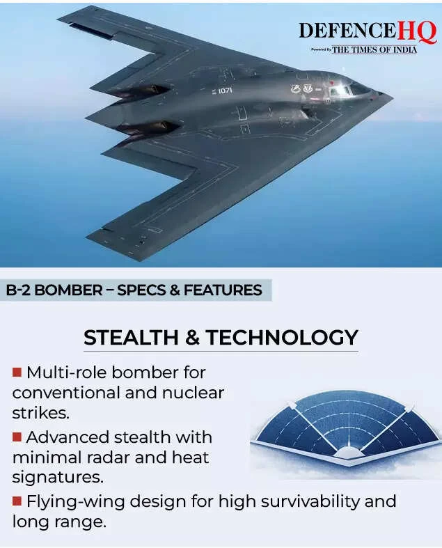
- ‘Dropped 2,000-pound bombs’: US launches B-2 bombers to dismantle Iran’s missile production capabilities
- Did Sakura Shymko move on with Kick streamer Drago after JasonTheWeen breakup? Viral yacht kiss clip leaves fans confused
- China was tracking the US location with satellites: The Chinese company had informed about the attack even before the first missile fell on Iran